About
As a passionate professional in the GIS and remote sensing field, I thrive on leveraging geospatial technologies to tackle complex challenges and uncover insights that drive decision-making. With a solid background in spatial analysis, data visualization, and environmental monitoring, I'm dedicated to harnessing the power of geospatial data to address real-world issues and contribute to sustainable solutions.

- Birthday: 28thDecember 2003
- Phone: +254 113143372
- Email: thukupeter487@gmail.com
- City: Nyahururu, Kenya
- Degree: Bsc GIS & Remote Sensing
- Freelance: Available
Resume
Summary
Innovative and deadline-driven Imagery Expert, Geospatial Developer with 3+ years
of experience anlyzing and developing user-centered Geospatial Oriented
Applications from initial concept to final, polished deliverable.
- Nyahururu, Kenya
- (+254) 113143372
- thukupeter487@gmail.com
Education
BSc GIS & Remote Sensing, 2021 - 2025
Certificate in African Space Strategy & Policy
Certificate in Drone & Data Academy
Dedan Kimathi University of Technology ( DeKUT ), Nyeri, Kenya
African Space Leadership Institute ( ASLI )
African Drone & Data Academy ( ADDA )
Professional Experience
Geospatial Developer & Imagery Intelligence Specialist
2023 - Present
Remote Freelance
- Reaserch, Development, and Implementation of the UI layout,
and production of Geospatial Applications. - Field Surveying, GeoSpatial Data Collection, Analysis & Visualization by utilizing various Tools & Platforms.
- OpenEO Imagery Analysis across various platforms; GEE, Jupyter Notebooks.
Research Attachee
January 2024 - April 2024
GeoSURV Systems Ltd, Nairobi, Kenya
- Undertook Cadastral Boundary Surveys ( Road Reserve Surveys ).
- Tasked on Spatial Planning - Parcel Subdivision & On-Ground Beacon monumentation.
- Created Survey Plans, Deed Plans, Surveyor's Reports among other Official Documentations.
Portfolio
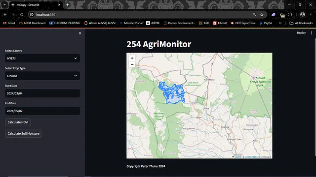
As a dedicated professional in this field, I have leveraged cutting-edge technologies and spatial analysis techniques to tackle complex geospatial challenges. From mapping and spatial data analysis to remote sensing applications, my portfolio demonstrates a diverse range of projects and accomplishments.
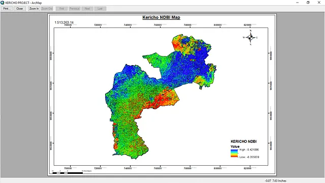
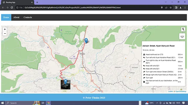
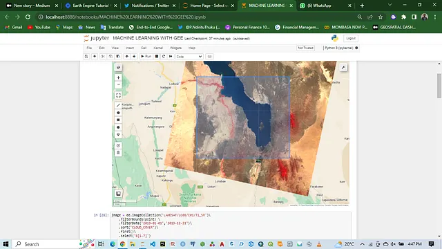
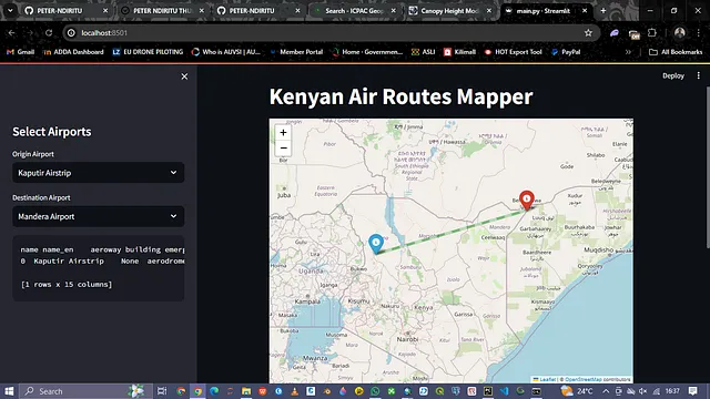
- Geospatial Sample Projects


Honors & Awards
Certificate (s) in Scientific Manuscript Research Peer Review. Issued by B P International on 8thJanuary 2024, 20th & 15th December 2023
Certificate in African Space Strategy & Policy. Issued by African Space Leadership Institute ( ASLI ) on 14th December 2023
Certificate in SuperMap Software Training. Issued by DRSRS & SuperMap on 23rd November 2023
Certificate of Merit Academic Year 2022/2023 ( 1st Position ). Issued by DeKUT on 15th November 2023
Certificate in European Union Remote Pilot License ( EU RPL ). Issued by European Union Aviation Safety Authority ( EASA ), EU Control on 25thOctober 2023
Certificate in Drone & Data Technology Level 1. Issued by Virginia Tech, Furman University, and MUST on 20th October 2023
Certificate in Trusted Operator Program (TOP) Level 1. Issued by Association of Uncrewed Vehicle Systems International (AUVSI) on 20th October 2023
Certificate in Wetlands Vulnerability Analysis Training. Issued by RCMRD, Makerere University , AGRC2023 , GMES & Africa on 15th August 2023
Certificate in Cartography. Issued by ESRI on 3rdApril 2023
Certificate in Introduction to Artificial Intelligence. Issued by SkillUP by Simplilearn on 10th February 2023
Certificate in Data Visualization Using Python. Issued by Great Learning Academy on 3rd February 2023
Certificate in DEA Water Resources. Issued by Digital Earth Africa on 26th January 2023
Certificate in Introduction to Digital Earth Africa Sandbox. Issued by Digital Earth Africa on 25thJanuary 2023
Certificate of Merit Academic Year 2021/2022 ( 1st Position ). Issued by DeKUT on 14th November 2023
Certificate in Computer Studies. Issued by St. Anne's Catholic Institute on 23rd September 2021
Contact
Are you're interested in discussing Geospatial analysis, Remote Sensing Applications, or potential partnerships, I'm here to connect. Feel free to drop me a message using the contacts below.
Location:
Remote, Kenya
Email:
thukupeter487@gmail.com
Call:
+254 113143372